Land constraints & overlays / MORNINGTON PENINSULA
DDO2 and EMO7: planning an extension on a sloping block
A lower roof can mean more excavation. Check how DDO2 and EMO7 interact and prepare one set of drawings for the project team.
Get design and ground advice onto one revision
Show the space you need, current concept, available levels and proposed earthworks. Ask which missing fact could change the option before commissioning detailed work.
Prepare a slope-project brief →On a block affected by both DDO2 and EMO7, changing the building's height can also change its excavation, drainage and geotechnical assessment. Before paying to develop one design in detail, establish which decisions could change the whole concept.
DDO2 addresses matters including building form, neighbourhood character and views. EMO7 addresses landslide risk. Meeting one control does not establish compliance with the other, and a permit exemption under one does not remove a permit requirement under the other.
This guide uses Mornington Peninsula's DDO2. If your property report lists DDO1, DDO3 or another number, read that schedule instead.
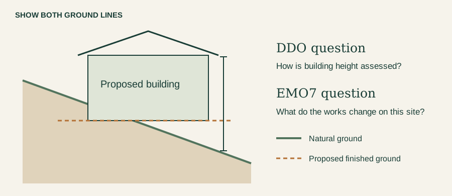
Two controls, different questions
Start with a current VicPlan property report and mark the project on the overlay map. EMO7 mapping changed in October 2026, so reuse the site measurements where appropriate but refresh an older overlay report. Council explains the change on its C314morn page.
| Control | Question to resolve | Evidence to put on the shared drawings |
|---|---|---|
| DDO2 | Does the design qualify for its permit exemption; if not, what must the application address? | Natural ground, building and wall heights, finished levels, earthworks, setbacks and relevant surrounding buildings. |
| EMO7 | Which buildings and works need a permit, and what geotechnical information is required? | The mapped area, work locations, earthworks, retaining structures, drainage and relevant existing site conditions. |
This is a coordination checklist, not an alternative to the schedules. A property can also have vegetation, bushfire or other controls, and a building permit remains a separate question.
The DDO2 numbers are not a complete design envelope
Under DDO2's General requirements, wall height is limited to 5.5 m and building height to 6 m. The difference between finished and natural ground created by excavation or filling must not exceed 1 m, with an exception for constructing an in-ground pool.
For a single dwelling, extension or outbuilding, the DDO2 permit exemption depends on meeting all General requirements, not just height. Mandatory requirements still apply. There are separate mandatory height provisions and location-specific exceptions; 6 m is not a universal maximum for every DDO2 property.
A design outside a General requirement needs the relevant permit assessment. It is neither automatically acceptable nor automatically prohibited. Do not carry DDO2's pool exception into EMO7: that is a different control with different permit provisions.
Compare the space you gain with the work each option creates
Suppose a family wants more living space on a sloping block. The first concept extends downhill, but its height raises a DDO2 question. “Lower the floor” is one possible change—not the owner's underlying objective.
Ask the designer to compare a small number of concepts against the space needed, budget, access and features the family wants to retain. This hypothetical comparison shows the questions to carry into that discussion:
| Concept change | What it might achieve | What needs checking again |
|---|---|---|
| Lower the floor and roof | Reduce visible building height | Deeper uphill excavation, retaining structures, drainage and geotechnical implications. |
| Keep higher floor levels | Reduce some excavation | Building height, access, external appearance and the case for any permitted departure. |
| Change the footprint or room arrangement | Move some work away from the difficult part of the site | Whether the space still works; new setbacks, vegetation impacts and site works. |
None is inherently cheaper, safer or approvable. Compare them on the same section drawing, with the changed levels and works marked. Avoiding one permit trigger is not a useful saving if the resulting design creates greater construction cost or loses the space you need.
Resolve the uncertainty that could rule out an option
Reuse any suitable survey and existing reports. Ask the designer which missing measurements prevent a meaningful comparison. The drawings need natural and proposed ground shown separately, sections through the most altered areas, excavation limits and retaining structures—not just finished walls and roof.
Council says its online contour information is indicative and must not be used for planning or building applications on its zones and overlays page. Have the team identify which measured information is missing before relying on a map screenshot.
If ground conditions could change the feasibility of an option, seek geotechnical input before settling the layout. Ask what advice can usefully be given at concept stage and what investigation it needs. If the uncertainty concerns how a planning requirement applies to an adequately described design, take that question to Council or a planner. These tasks do not always follow a Council-first sequence.
Commission the next piece of work against one agreed concept
The EMO7 report guide distinguishes permit exemptions, discretionary assessment waivers, Geotechnical Assessments and Landslide Risk Assessments. None is determined simply by being below DDO2's height or earthworks figure.
Use the comparison to agree which concept is worth developing and which questions remain. Give each adviser the same dated drawing revision and relevant correspondence. Ask for a specific deliverable:
- Designer: a concept showing the usable space, levels and associated works, with unresolved measurements identified.
- Council or planner: the applicable permit questions, any departure being sought and information needed for assessment. Council's general enquiry guidance explains the details needed for a specific response.
- Geotechnical practitioner: the appropriate assessment scope, information and investigation required, and which design changes would require the advice to be revisited.
Ask each quotation to identify the drawings and existing information it assumes, its deliverables and exclusions. This makes differences in scope visible before comparing prices. A concept review cannot be assumed to replace a required report or investigation.
When advice comes back, record what it resolves and what still blocks the next stage. If floor levels, retaining walls, footprint or drainage change, send that revision to the advisers whose conclusions depend on it before paying for further detailed work.
Where AI helps with the handover
Ask AI to compare the dated concept notes and adviser responses, listing changed dimensions, unanswered questions and which conclusions refer to an older revision. Check that list yourself before sending it to the team.
AI cannot validate excavation stability, select a footing design or replace the EMO7 practitioner's assessment. Professional engineering work also has registration requirements and defined exemptions, separate from the incorporated document's practitioner test. Ask the consultant to identify the responsible author and relevant credentials; do not commission only a signature on an AI-generated design.
WHAT TO GATHER
Compare options using both ground lines
A lower roof may require more excavation. Ask for the effects of each concept to be explained together.
Existing ground
Identify the source and limits of available survey or level information.
Proposed work
Show floor levels, cut and fill, retaining structures and known drainage on the same revision.
Decision
Record what each option gives you and which design or ground uncertainty remains unanswered.
Get design and ground advice onto one revision
Show the space you need, current concept, available levels and proposed earthworks. Ask which missing fact could change the option before commissioning detailed work.
Prepare a slope-project brief →