Land constraints & overlays / MORNINGTON PENINSULA
EMO7: can I build a shed, deck or extension?
Check the current EMO7 map, the permit rules for your work and the geotechnical information needed before commissioning a report.
Separate the permit question from the report scope
Bring the current map, marked concept and available ground and drainage information together. Identify what needs planning clarification and what needs a practitioner’s assessment.
Prepare an EMO7 brief →EMO7 does not automatically stop you building, or require every owner to commission a landslide report. First establish whether your proposed work is inside the current overlay. Then check whether that work needs an EMO7 permit. If it does, establish what geotechnical information must accompany the application.
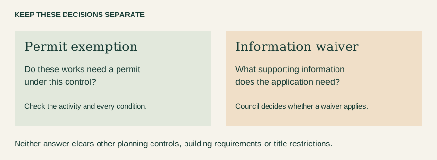
These are separate questions. A waiver of a report does not waive a planning permit. An EMO7 exemption does not clear the project under a Design and Development Overlay, another planning control or the building-permit process.
Before paying for a report, check the current map
Has EMO7 changed on your property? Amendment C314morn has applied since its gazettal/operation on 15 October 2026, according to the official amendment register. Council’s chronology separately labels 19 October 2026 as approval. Those published date labels differ, so keep both with their source instead of declaring an inferred legal date. The revised map affects substantially fewer properties, but your latest VicPlan report and the project footprint—not the Shire-wide count—determine what to ask next.
The October 2026 update changed EMO7's boundaries and requirements. An early-2026 property report may no longer describe your land. Council's C314morn update page explains the remapping and links to its comparison map.
Get a new report from VicPlan. Mark the proposed building, excavation, retaining walls and drainage works on a site plan. Compare those locations with the mapped boundary; identifying an overlay somewhere on a large lot is not enough to locate the affected work.
Save the report with its download date. Reuse existing permits, survey information and drainage records. Mark missing facts rather than paying to recreate information you already hold. If the boundary cuts through the project, the enquiry needs a marked plan—not just an address.
There is no single “under 20 square metres” answer
Read the current Clause 44.01 and Schedule 7 in the Victorian planning scheme alongside the C314morn amendment record. Check that the document heading identifies C314morn rather than the superseded January 2026 C312morn schedule: an older generated PDF was returned during a 9 November retrieval, despite an earlier review capturing a newer version. If the schedule version cannot be confirmed, do not treat any numerical threshold as an operative exemption. The work categories below are questions to confirm, not permit verdicts:
| Proposed work | What needs checking under EMO7 |
|---|---|
| A new building without accommodation | Check the construction materials, distance from specified existing earthworks and drainage conditions in the building exemption. Assess associated excavation and retaining work separately. |
| An alteration or extension | Check the separate extension exemption’s existing-earthworks and drainage conditions. Its operative wording does not repeat a 20 m² limit; associated works still need checking. |
| Earthworks, including retaining structures | The exemption has an area ceiling of 20 m². Excavation depth, fill height, or their combination must not exceed 1 m within a horizontal distance of 5 m. |
| Work listed in Clause 62.02-2 | EMO7 specifies a permit trigger above 20 m², for excavation/fill exceeding 1 m within 5 m horizontally, or for on-site absorption, detention or infiltration drainage. Check how the schedule’s specific exemptions apply. |
For the first two rows, the conditions include more than 5 m separation from existing earthworks exceeding 1 m excavation/fill within 5 m horizontally, connection to a legal point of discharge and no on-site absorption, detention or ground infiltration. Before relying on these conditions, verify the document header and the exact current clauses through the live planning scheme and Council C314morn guidance. An older C312morn document and Council’s retained draft are not evidence of the operative exemption.
Do not assess the building while leaving its excavation or retaining wall out of the enquiry. A deck attached to a house also needs its correct classification established; its marketing name and floor area cannot settle the permit question.
If a permit is needed, which report?
The operative July 2026 geotechnical requirements distinguish these routes:
| Route | What it means |
|---|---|
| Council agrees to waive the assessment | Clause 5.1 allows Council to consider demonstrated natural slopes within 50 m of the proposed buildings and works: maximum 8° for Balcombe Clay, Baxter Sandstone, Older Volcanics and Siltstone Soils, or 14° for Devonian Granite and Quaternary Sands. Alternatively, a qualified practitioner supplies a statement and Form D addressing absence of credible landslide hazards and previous landslide on the site. |
| Geotechnical Assessment | Unless waived, Clause 5.2 requires a site-specific assessment. For buildings and works, this includes Form A and a conclusion about significant landslide hazards. |
| Landslide Risk Assessment | Clause 5.3 applies where significant landslide hazards require further risk assessment. It is not automatically the first report for every small project. |
Council may waive an assessment; a slope estimate does not approve a waiver. Geological classification and off-site conditions need evidence. The practitioner can require intrusive investigation at any stage: these routes are not a promise that drilling can always wait.
A small-deck example: what needs resolving first?
Suppose you want an 18 m² deck beside an existing retaining wall. The aim is usable outdoor space; the exact shape and position may be flexible. “Under 20 m²” does not settle the deck's classification, nearby earthworks, construction excavation or drainage.
Start with photographs, available drawings and a marked concept. Ask the designer to identify which missing measurements could change the layout. If the uncertainty is how the schedule applies to known work, a focused Council enquiry is useful. If the retaining wall or ground conditions could determine whether the concept is feasible, ask a geotechnical practitioner what initial advice and information are needed. A map screenshot cannot resolve that physical question.
Keep an alternative position open until those answers arrive. Moving the deck may change the issues; it does not establish that the alternative is exempt or safe.
Ask for an answer you can use
For a Council enquiry, attach the current property report, dated concept, available survey, photographs, relevant title and permit records, and known drainage details. State which facts remain unconfirmed. Ask which parts of the proposal need an EMO7 permit and what evidence would support any Clause 5.1 waiver request. Check the enquiry service's requirements before submitting; an informal email is not a guaranteed written assessment.
For a geotechnical quotation, request a scope that identifies:
- The question the work will answer and the drawing revision assessed.
- Existing information that can be reused, and missing information or investigation required.
- The report and declarations to be delivered, including whether further assessment may follow.
A preliminary review, where the practitioner considers it appropriate, is not a substitute for required assessment. Agree the scope before authorising work; do not assume every quote labelled “EMO7 report” covers the same deliverable.
Keep Council's response and the practitioner's advice with the drawings. If the layout changes, ask which conclusions need revisiting before commissioning the next stage. For interacting height and slope issues, see DDO2 and EMO7 on a sloping block.
AI preparation and the required practitioner
AI can turn Council's request into a quotation checklist and identify which documents or measurements are missing. It cannot establish the site's geology, landslide history or risk, or supply a practitioner's declaration.
Section 1 of the linked July 2026 document specifies a degree-qualified geotechnical engineer or engineering geologist with relevant slope-stability and landslide experience and one of its listed current professional statuses. Ask the quote to name the author and how they meet that definition. The practitioner supplies any required assessment or Form D statement; Council decides whether to waive the assessment. An AI-written report does not fulfil either role.
WHAT TO GATHER
Mark all the work, not just the building
A shed or deck enquiry needs to show associated excavation, retaining structures and drainage works too.
Current map
Save a dated property report. Mark where the proposed work falls relative to the overlay boundary.
One concept
Use one drawing revision for the building, excavation, retaining walls and known drainage details.
Missing evidence
List ground levels, nearby earthworks and drainage information you cannot confirm. Ask who should establish each item.
Separate the permit question from the report scope
Bring the current map, marked concept and available ground and drainage information together. Identify what needs planning clarification and what needs a practitioner’s assessment.
Prepare an EMO7 brief →